|
Back
to top
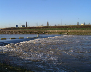
The Flood Relief Channel
upsets residents downstream
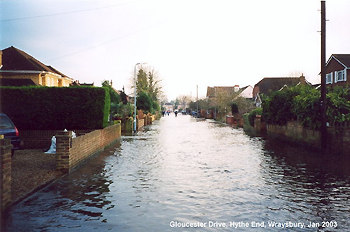 Gloucester Drive,
Hythe End, Wraysbury
Gloucester Drive,
Hythe End, Wraysbury
3.00pm on Sunday 5th January about 6 hours before "High
Tide".
(With thanks to Les Willis of Gloucester Drive for
sending this to us)
Letter to the Editor, Thamesweb.
January 7th 2003
I am glad all the residents
in Maidenhead were safe but what about all the poor people further
down the river in Wraysbury.
It is not surprising that the residents in Maidenhead
were only on a Flood Watch on Saturday night and the residents
of Datchet and Wraysbury were on a severe warning, as this could
only have been caused by the Jubilee River.
Many residents have lost their cars, as they were
unable to move them in time before the flood waters reached their
properties. Many residents are still stranded and unable to move
their cars. The water was above the door sills of many of them.
Fortunately my daughter had gone out for the evening and when
she returned our front garden was under water. We had already
moved our cars to higher ground earlier in the evening. The water
level rose to such an extent that in 3 hours we had 2 1/2 feet
of water in our back gardens, and escaped substantial damage
by just 1/2". As our road is still on cesspits, we are unable
to use our toilets, have baths, do washing etc. It will be days
if not weeks before we can actually use these facilities. The
houses that have been severely affected are not the ones directly
on the river, our house is some 500 yards from the Thames and
there is a large area encompassing Ouseley Road, Wharf Road,
Coppice Drive, Garson Lane, Riverside, Friary Road and The Embankment
that has been affected.
How many houses were actually flooded in Maidenhead
in November 2000 compared to the number of houses that have been
flooded in Wraysbury? I would imagine more in Wraysbury have
been affected and this is of course due to the volume of water
that has been pushed into the Thames at Datchet via the Jubilee
River. How can twice as much water be put in the river at Datchet
and the areas lower down not be affected?
Unhappy resident
The Jubilee River scheme
sounds wonderful for the people it was designed to protect. However,
it appears to me that this protection has been achieved at the
expense of those living further downstream. What measures are
being considered for present and future flood relief in these
previously unaffected areas?
Chertsey resident
Reply from the Editor,
Thamesweb
May I from the outset send
my sincerest sympathy for the situation that you find yourself
in. I am sure you will understand that as editor of the
privately run Royal Windsor Web Site I hold no brief for the
Environment Agency, nor have any connection with them, and for
two years I have been concerned, as you, that the Flood Relief
Scheme would deliver water faster to Datchet and downstream than
the existing river course could handle.
However, I have changed by mind in the last few days
and now believe that in order to deliver additional flood water
or accelerate delivery downstream, it must accept additional
water from upstream in order to do so. In this case the result
would be a draining away of the water upstream. This has not
been the case. The truth is that the Jubilee River merely divides
the flow arriving at Boulters Weir, splitting it between the
Thames and the Jubilee River such that the levels in the reaches
downstream as far as Romney Lock are lowered or 'shared' between
the two waterways. The amount of water delivered into Datchet
Reach at Black Potts is exactly the same as the amount of water
arriving at Boulters Lock, bar minor additions from streams feeding
the river between Maidenhead and Windsor. It is entirely coincidental
that the first real use of the Jubilee River resulted in the
first significant flooding downstream since 1947 (perhaps with
local exceptions). The truth is that, regardless of the new channel,
the Thames would have flooded severely as a result of the massive
amounts of water accumulating in the valley throughout its length
and for a prolonged period. I am attempting to get river levels,
flows and historical data from the Environment Agency to prove
this point as I do understand your view, which, as I say, I shared
too throughout the construction of the flood relief scheme. When
these figures are to hand it may be easier to determine which
argument is actually true.
The main point that remains is the morality of spending
£80 million on the scheme for the benefit of some, while
spending substantially less upstream or downstream. Eton College
may well have benefitted substantially through income from the
sales of gravel, etc., as well as the income from land released
for the project. Maidenhead and Bray was the prime beneficiary
of this scheme, and Windsor too, and it is the flooding in 1990
of properties built on the Maidenhead flood plain, contrary to
informed advice from various concerned agencies, that finally
precipitated the channel's construction.
What the future holds we cannot tell, but in order
for the risk of flooding to be almost totally removed throughout
the length of the Thames Valley, we need a second river to accommodate
the excess water. This will almost certainly lead to the loss
of homes and businesses in its path. It is debatable whether
this is acceptable, given that we are talking (currently) about
a 'once in 60 year' timescale. It should be noted that in Victorian
times floods of this regularity and height were far more common.
We may be returning to those times, but as yet we do not know,
and cannot predict the need for a 'full length' second channel.
Finally, I would point out that the Environment Agency
issued a Flood Warning (Flood
Warning - Flooding
expected affecting homes, businesses and main roads. Act now!)
at 10.33 on 1st January yet it seems that many people failed
to take note, thinking no doubt that there was nothing they needed
to do or that it did not concern them. The Severe Flood Warning was issued on Saturday night at
9pm (SEVERE FLOOD WARNING means serious flooding is expected.
There is imminent danger to life and property. Act now!). Whilst
I am not aware of when cars and property in your area were actually
affected, the peak levels did not occur until late on Sunday
afternoon which suggests that sufficient warning was given, but
some residents were too slow in taking action. The truth of the
matter is of course that if water wants to go somewhere, it will,
and that the only action that residents can reasonably take is
to remove items of value out of reach of the rising water. It
is sad to note that EA publicity in October given to the possibilities
of future flooding, and the need to plan for one's own area if
flooding is likely, have not been heeded by some.
As a Windsor resident all my life, and my father
before me, who was closely involved with the Floods of 1947 as Assistant Borough Engineer,
I can only have great sympathy for those affected over the last
few days. We missed another '47 by a whisker.
With my best regards
Editor
9th January 2003
I have just read your email with regard
to the recent flooding. Thankfully my house was not flooded and
no serious damage has occurred to my property, apart from my
poor garden. However I do think you are missing the point that
people in the Wraysbury area are trying to make about the Jubilee
River.
No one doubts the river levels were high
and would have flooded regardless. However, before construction
of the relief scheme, everyone along the path of the river would
have had a share of this flooding instead of it being shunted
along and trapped between Old Windsor and Leyland. We then suffered
not only our own share but also the volume of water that would
have dispersed over the Maidenhead, Dorney and Windsor area.
The lock at Shepperton was closed and the Thames Barrier raised.
This is what is upsetting so many of the residents. Can you ethically
save one area at the expense of another without any consultation?
Your point about the flood warning slightly
irritated me. As soon as I received the flood warning leaflet
asking me to ring up to get a short dial number I did. This was
not an easy thing to do and took several phone calls over several
days before I managed to get through and get the short dial number
for my area. On Saturday I tried to get the flood warning for
my area using this number only to be given the warning for the
River Ash. I held out again and dialled the complete number and
waited patiently until for the whole thing to roll through until
we came to the Windsor area. The voice then tailed of to a soft
tone repeating the words "three... three....three".
I dialled this several times getting the same response before
giving up!
On the Saturday a lorry with sandbags came
down the road and gave me the number to ring to order some. I
explained to the woman on the end of the phone that the river
was already up to the house wall and would that I like some sandbags
as soon as possible please. She told me in no uncertain terms
that I would not get any until my house had been inspected. There
were inspectors in the area and I would have to wait until one
came round and certified that I was close to flooding!!
The people of the flooding telephone line
know what has caused so much misery here. I spoke to one person
and said that I would hate to think that the Dorney Wildfowl
conservation area had flooded. I couldn't bear to think of all
those Ducks getting wet feet, or the cows on Dorney Common. He
only laughed and said that although he couldn't comment, if he
told me that Maidenhead was clear I could make my own mind up!
Have you got any response to that?
Many thanks for further
news from your area and your experiences. I have just read the
local Windsor Express which has of course given great coverage
to the floods and the claims that The Flood Relief has contributed
towards the problems downstream. I shall be pursuing the EA more
vigorously now having had a chance to tour the Ouseley Road area
myself last night and seen more clearly just how bad the flooding
was for some residents. The only proof available to us one way
or the other regarding the Scheme is to study the water flows
and volumes at each end of it and between Maidenhead and Windsor.
This should tell the true story. However, I am concerned by two
stories that I have heard. One that a gate got stuck at Boulters
Weir affecting the flow into the Flood Relief one way or another,
and another that Teddington closed up too soon before a high
incoming tide. I don't think either story has much bearing on
our area. But we need to investigate!
I am sorry that you have had trouble with the Flood Line. To
be honest I have rung it many times over the past two years in
times of high river levels before placing updates on The Royal
Windsor Web Site and have always got through to the right area
every time.
We then suffered not only
our own share but also the volume of water that would have dispersed
over the Maidenhead, Dorney and Windsor area. The lock at Shepperton
was closed and the Thames Barrier raised. This is what is upsetting
so many of the residents. Can you ethically save one area at
the expense of another without any consultation?
This is the point we must
pursue vigorously with the EA. I think that with the volumes
of water arriving from upstream of Maidenhead, the 'absorbent'
effect of Dorney Common etc. would merely have delayed the events
downstream, not reduced or removed them. This is simply because
once Dorney was full, for example, the water would have still
flowed on downstream, just later. The relevant aspect is the
the volume of water that had to flow from above Maidenhead
through our area to the sea, come what may. We must get answers
from EA engineers to determine if flooding Dorney, or the rest
of us, would have made any difference overall.
The point about Shepperton is interesting although one would
expect the Lock to be closed anyway. Was Shepperton Weir closed?
If so one must find out the reasons. I have just talked with
the Information Centre at the Thames Barrier, Woolwich who tell
me that the barrier has been raised twice a day ever since New
Year. Again, I need to find out to what extent this constant
raising of the barrier has slowed flows out of the Thames and
if water levels have 'backed up' as far as our area as a result.
It seems unlikely.
As to the ethics of the matter, I think most people would agree
that if you can save some areas, then one should do so. The financial
costs of flooding a large number of businesses upstream, closing
many roads and inflicting damage on a vast number of additional
properties cannot be supported - quite apart from the massive
increases in insurance claims which we all have to pay for in
the long run. Without the Flood Relief Scheme the damage upstream
would have been substantially greater. The fact remains that
the last week or so has seen massive flows of water, close to
1947 levels, and the Flood Relief has done exactly what it was
intended to do which was to avoid these massive expenses over
a wide area. As I said in my original letter, these are once
in 60 year occurrences and it is up to the population of the
area to decide if they want the massive cost and disruption of
a second river through an increasingly built up area, to drain
the river to the sea without flooding our reaches.
The matter of sandbags I suggest was simply due to
the sheer volume of demand. It is a shame that many residents
did not get their supply when they needed it, but equally there
were some residents who demanded sandbags even when others closer
to being flooded had not received theirs. Hence the need for
inspection. A valuable lesson here would be to establish a list
in priority and address order, based on the level of the property
in relation to the river. The lowest first! Then the need for
inspection would be removed as the authorities would know better
than individual residents which properties were most urgently
in need. I am reminded however of my late father's view that
sandbags were not much more than a public relations exercise
as water most commonly rises up through the drains, from under
the floor and up through the ground so have little effect other
than to cut down undue 'wash' from passing vehicles.
With my best regards
Editor
A View from
Staines
Firstly I would like to thank you for an
informative and interesting web site, and like many, I express
that, despite the fact that I'm going to make points about the
Jubilee River, I do not wish floods and the distress caused upon
any one.
I attended the EA's open forum on the 23rd and spent
a not inconsiderable time reviewing the information on display.
I have the following points.
- The important information was generally
presented in large quantities of complex graphs and tables.
- The graphics displaying the extent of
the 2003 event were incorrect. Based on areas that I personally
witnessed and photographed, the flood has been underestimated.
- The only real point of interest to residents
below the Jubilee river was the relative levels before and after
the introduction of the Jubilee River. This was presented on
two graphs, one on the Jubilee River stand. This used such
a ridiculous scale that the 3 lines indicating the floods of
1947, 2000, and 2003 where almost overlaid on top of each other.
Indeed, if you did look carefully, something strange was occurring
around the Old Windsor/Datchet region of the graph. The second
graph was hand drawn and indicated peak river levels in metres
from above the Jubilee River through to Chertsey for the three
floods. This graph was drawn at a sensible scale and clearly
shows that the peak levels prior to the Jubilee River for 2003
are fractionally above the 2000 flood i.e. approx. 10-20mm and
the level, where it exits the Jubilee River, is 300-400mm greater
(12 to 16 inches).
- A colleague of mine who was at the
forum with me returned in the evening to find the above graph
had been removed and the EA didn't know by who or why. Don't worry I took a photo of the relevant part.
- Despite the EA quoting that November and
December 2002 had twice their average rainfall, there was no
comparison available of 2000 and 1947. My research indicates
that the rainfall in November and December 2000 was almost identical
to 2002 and the 4 month period from September to December 2000
was one of the wettest recorded, second only to 1947.
In conclusion I do not feel the EA has
gone any way to proving that the Jubilee River is operating as
per their model in any respect other than defending the Maidenhead
and Windsor area. It doesn't take a genius to review the data
and realise their claims that the flood event was comparable
with 1947 only refers to the water levels and flooding of Datchet,
Wraysbury and Runnymede. Reading, Kingston, Teddington, Hackney,
Tottenham, Barking, etc certainly didn't see a repeat of 1947.
I apologise if this sounds like a bit of a rant,
I commend the EA for having the nerve to stand up and present
their case, but I trust them less now, having heard their spin,
than when the water was lapping at my door.
Regards
P.C. from Staines
Back
to top
An Open Letter from Mr Lawrence, the Leader of the Council
to the Environment Agency
9 January 2003
Sir John Hannan
Chairman
Environment Agency
25th Floor
Millbank Tower
21-24 Millbank
London
SWIP 4XL
Flooding in The Royal
Borough of Windsor and Maidenhead
We are now in the process
of dealing with the aftermath of recent flooding. As you are
aware, various areas within the Royal Borough of Windsor and
Maidenhead were adversely affected by the flooding, and the area
of Wraysbury was the eventual subject of a severe warning. Our
initial analysis suggests that areas that have been the subject
of flooding were not in your 1: 100 year Post Scheme floodplain.
A large number of the residents within the Wraysbury area are
now seeking the assistance of the Council in helping them return
their homes and the local area back to normal.
Viscount Mills, South East Regional Chairman, has advised Cookham
residents today that an investigation will now take place within
the Environment Agency. We would like the investigation to cover
our whole area and include:
i. Why properties either
previously not affected by flooding, or not previously affected
to this extent, suffered in the way that they did;
ii. How much the flood alleviation works completed in 2002 have
contributed to the severe flooding experienced, and
iii. Why there was a significant delay in issuing a severe warning
in respect of the Wraysbury area when the situation was quickly
becoming more serious than suggested by the flood watch warning
and when the more timely issue of a severe warning would have
permitted better preventative measures to be taken.
Such an investigation is
clearly needed but we would advocate that this should be carried
out by an expert independent of the Environment Agency. We would
expect to be consulted over the terms of reference and who will
conduct the review.
We would also expect such an investigation to address other important
issues such as those set out below, although an initial response
to these issues is requested:
a. What assistance is the
Environment Agency willing and able to offer to homeowners whose
properties were affected by the flooding both in terms of immediate
relief, and to address the possible difficulties such owners
will now face when attempting to sell or insure their properties
in the future?
b. Does the Environment Agency accept that it has inadequately
modeled the affect of the flood alleviation works to areas downstream
of Windsor to such an extent that no adequate steps were taken
to protect those properties affected from flooding, and that
therefore the Environment Agency is liable for the extent of
the flooding that has occurred?
c. What action is the Environment Agency proposing to take in
respect of potential future flooding in the area?
Given the urgency of this
matter and the degree of public concern it would be very helpful
to have a response to the issues raised within the next 7 days.
It is intended that this letter will me made publicly available,
including circulation to those residents affected by the flooding.
cc Mrs T May MP
Mr M Trend
MP Viscount Mills
Back
to top
Royal Borough Asks Questions
too
PRESS RELEASE
Thursday, 09 January 2003
Cabinet Calls For Independent Investigation Into Flooding
The Royal Borough is taking up the cudgels
on behalf of beleaguered residents by calling for an independent
investigation into the cause of this week's flooding in areas
like Cookham and Wraysbury.
As hundreds of local people struggle to recover from
severe water damage to their homes and businesses, council leader
Cllr Michael Lawrence has written to Sir John Harman, chairman
of the Environment Agency, making it clear that any investigation
must cover the questions currently being asked by despairing
flood victims:
- Why have properties never before affected
by flooding or not to such a great degree suffered
this time?
- To what extent has the Jubilee River contributed
to the situation?
- Why was there a significant delay in issuing
a severe flood warning for Wraysbury an earlier alert would
have given residents more time to take preventative action.
Cllr Lawrence said it was time for the
council to champion the cause of local people who were coming
to terms with the damage and the financial implications for them
and their families.
He said: "We cannot speculate at this
stage about why these floods were so severe but questions need
to be answered. Many people are left wondering if the Environment
Agency got its calculations wrong about the effects of the flood
alleviation scheme, leaving Wraysbury and other areas downstream
of Windsor completely unprotected and vulnerable as never before.
"Not only must there be a high level investigation
but it should be completely independent of the Environment Agency
so that Royal Borough residents can feel confident of an objective
review and outcome."
Cllr Lawrence has also asked the chairman what assistance
the Environment Agency will be offering to people whose homes
were hit by the floods, not only to help them with the immediate
clear-up but also with potential problems ahead when they try
to insure or sell their homes.
He said: "These are very real concerns
and I share the view that the Environment Agency must be asked
to come forward with much-needed support and, indeed, what action
they propose to take to make sure this week's fiasco doesn't
happen again."
Flooding was discussed as an urgent item during this
evening's cabinet when members were given a review of the council's
24-hour-a-day response to residents' calls for help and advice
throughout the emergency.
Back
to top
Where has all
the water gone??
Extract from Cookham
News (29th November
2000)
"Mr R Powling, Project Manager for
the Agency, described the work now in progress on the flood relief
channel and its projected effect on river levels, an anticipated
reduction of water height above Boulters Lock of 1' 6" reducing
to 1" by Cookham Bridge. Full report
"
This is most strange. An
official claims in November 2000 that river levels will be reduced
by 45cm (1' 6") upstream of The Flood Relief Channel intake
at Boulters Weir, that river levels will remain below flood level
throughout the river from Maidenhead to downstream of Windsor,
and that residents in these downstream areas will not be adversely
affected by a rise in river levels as a result of the opening
of The Flood Relief Channel. It seems that somewhere there is
an awful lot of water left unaccounted for...
Back
to top
Environment Agency Report
On 13th January 2003 The Environment Agency
reported that the Thames Barrier at Woolwich had been closed
a record 14 consecutive times between New Years' Day and 8 January
2003 as the combination of high incoming tides, coupled with
increased flows from upstream meant there was a real risk of
flooding within the London area, especially underground transport
and low lying residential areas.
The EA
also reported that rainfall along the Thames Valley since 1st
November 2002 at 261mm [over 5"] was 'more than double the
average [136mm - 2.6"] and from 21 December to 31 December,
86mm [almost 3.5"] of rain fell in the region, more than
the average for the whole month. This heavy rainfall pushed river
levels on the Thames to their highest since 1947, and the third
highest in 120 years'.
'At their peak, river levels flowing over Teddington
Weir were three times greater than average winter levels
with over 9,000 million gallons of water a day flowing through
the weir the equivalent in volume of 220,000 Olympic swimming
pools of water flowing through Teddington a day.'
'High flows moving downstream combined with tidal
flows over 3 feet (1 metre) higher than a regular high tide,
meant river levels in London rose 4 feet (1.2 metres) above what
would normally have been expected.'
Back
to top
Previous floods - water
volume data
We have researched the
following figures for volumes of flood water during previous
floods. (Source Maidenhead Flood Study 1986) These figures
will be similar or slightly greater downstream where additional
watercourses join the river.
| Date |
Return Period |
Min. Peak Flow
(Cumecs) |
Max. Peak Flow
(Cumecs) |
| November
1894 |
100 |
480 |
600 |
| March 1947 * |
60 |
420 |
535 |
| January
1959 |
6 |
270 |
360 |
| November
1974 |
4 |
245 |
335 |
* This resulted
in a peak flood height in Windsor of 6' 8"
Environment Agency Web Site
See also
The Daily Telegraph, Wednesday January 8th 2003
Page 3
As of January 2003 this story is
available following a search for 'Jubilee River'. However, you
will need to register with the web site to read the story. It
is titled "We warned them it would happen but they believed
their computer"
By Charles Clover, Environment Editor.

To contact us, email
Thamesweb.
|