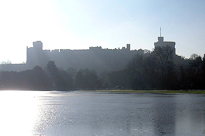
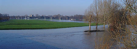
Apparently the
river, but in fact flood water over the Home Park at the point
where the Horse
Show and All The
Queen's Horses took place in May 2002.
This photo taken Sunday 5th January 2003 at 10.30am
As the floods
have now receded, this page will only be updated if additional
reports and photographs are received. Correspondence and other
information in the aftermath has been included here -- The
Aftermath.
If flooding returns in the future, we will resume daily reports
and pictures on our Home
Page.
We would welcome additional pictures of the floods in this area
for inclusion on the Royal Windsor Web Site.
Introduction - The days
before the flood
November and December 2002
had been exceptionally wet months, and the period around Christmas
particularly so. Rainfall along the Thames Valley since 1st November
2002 was reported to be 261mm [over 5"] and more than double
the average of 136mm [2.6"]. From 21 December to 31 December,
86mm [almost 3.5"] of rain fell in the region, more than
the average for the whole month. The result was that by the New
Year of 2002/3 there were numerous areas affected by minor floods
not just in the Thames Valley, but throughout the UK.
In Windsor the river started to rise significantly from
the New Year, not peaking until the weekend of January 4th/5th.
A Flood Watch had been instigated
by the Environment Agency at 2.40pm on Thursday 2nd January.
The Jubilee River was put in to operation, diverting water from
upstream of Boulters Lock in Maidenhead and returning it to the
river below Windsor, at Black Potts railway bridge, in the Datchet
to Old Windsor reach.
On Friday 3rd January it was seen that levels below
Windsor reach were very high, higher than in 2000, and the Environment
Agency issued a Flood Warning indicating that main roads and property were liable
to flooding. On Saturday evening at 9pm this was upgraded to
a Severe Flood Warning where "serious
flooding is expected. There is imminent danger to life and property.
Act now!" (Environment Agency
wording).
Windsor had been issued only with a Flood Watch where
flooding was considered possible, though not necessarily in any
areas where property might be affected.
Saturday 4th January 2003
By Saturday midday levels in Windsor had
exceeded the levels seen in mid-December
2000, the last time that the river had been significantly
high. By Saturday evening large areas of the Home Park had been
flooded.
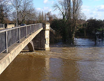
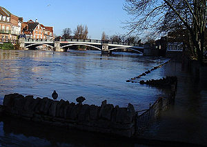 Windsor Bridge from upstream
5th January 2003
In the picture above the promenade walkway
is flooded, and the wall (top right) almost submerged, with river
levels a few inches higher than in December 2000. By Saturday
evening this wall was underwater.
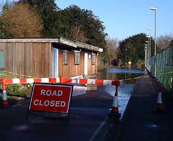
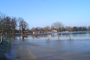
The access road in Windsor Home Park. 5th January 2003
In the Home Park on Saturday morning the
east car park and road leading to it had been closed. On Friday
evening this road was still dry. By Saturday evening the levels
had risen a further 6".
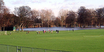 Saturday morning training went
ahead, just...
Saturday morning training went
ahead, just...
4th January 2003
 Club huts marooned as the water
submerged the Home Park.
Club huts marooned as the water
submerged the Home Park.
4th January 2003
Saturday morning, 4th January,
the area of the 18th century Maastricht Lake is submerged beside
the Windsor - Datchet road.
The pond here is created by the rising ground water, the area
of which grew significantly throughout Saturday.
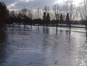
A view downstream from Victoria
Bridge showing the flood waters have extended over a considerable
distance into the private areas of the Home Park around an area
known as (Molly) Dodds Hill.
 A view of the water flowing around
Victoria Bridge
A view of the water flowing around
Victoria Bridge
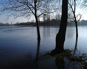
Sunday 5th January 2003
 The view from Victoria
Bridge over the Home Park.
The view from Victoria
Bridge over the Home Park.
5th January 2003
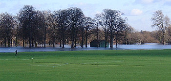
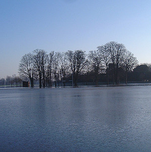
By Sunday morning, 5th
January, the river had inundated large areas of the Home Park
at Windsor as the river in the reach below Romney Lock continued
to rise. The following photographs show extensive flooding right
across the playing fields.
 From Datchet Road
looking north towards the club houses on the far side
From Datchet Road
looking north towards the club houses on the far side
5th January 2003
 A surreal scene
from amongst the trees by the Rugby Clubhouse
A surreal scene
from amongst the trees by the Rugby Clubhouse
5th January 2003
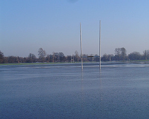 No play today...
 Looking south east
across towards the Datchet Road
Looking south east
across towards the Datchet Road
5th January 2003
The Severe Flood Warning issued at 9pm Saturday evening was revised by
the Environment Agency in the recorded announcement issued on
Sunday at 2.15pm. This emphasised the danger of flooding particularly
in the Wraysbury, Staines and Laleham areas. Windsor reach remained
only at Flood Watch, demonstrating the effectiveness
of the Jubilee River in keeping river level below danger level
around the town.
By 3pm at the western level crossing in Datchet,
water was seen between the rails and the crossing was being manually
operated. Steam was seen rising from around the insulators supporting
the live electric rail and a small stream of water was running
down from the track along the kerbside forming a growing puddle
in the exit road in the Slough direction, outside the Used Car
Sales garage. By 5pm this had spread across to the middle of
the road and the railway was closed as flood water submerged
the track. Train services were suspended out of Windsor and Eton
Riverside to Waterloo soon after. South West Trains announced
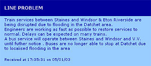
"Train services
between Staines and Windsor & Eton Riverside are being disrupted
due to flooding in the Datchet area. Engineers are working as
fast as possible to restore services to normal. Delays can be
expected on many trains. A bus service will operate between Staines
and Windsor and V.V. until futher notice . Buses are no longer
able to stop at Datchet due to localised flooding in the area."
Meanwhile,
downstream in Wraysbury the river was rising fast and we received
this picture from Les Willis, Gloucester Drive, Hythe End, Wraysbury.
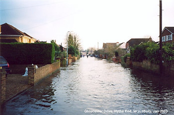 Gloucester Drive,
Hythe End, Wraysbury
Gloucester Drive,
Hythe End, Wraysbury
3.00pm on Sunday 5th January about 6 hours before "High
Tide".
(With thanks to Les Willis of Gloucester Drive for
sending this to us)
Monday 6th January 2003
There has been little change
in the levels in Windsor reach and down stream at Datchet overnight
and the Environment Agency in their telephone Flood Line Announcement
issued at 10.30am on Monday 6th January indicate that river levels
would remain high but by 3.00pm the Datchet Reach had fallen
by several inches. At Windsor too levels had begun to fall slowly.
There was a hard frost last night, and Monday has been clear
and sunny. The Windsor to Waterloo line remains suspended between
Windsor and Staines due to flooding at Datchet, pictured below.
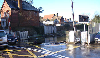
The flooded railway
level crossing and submerged rails at Datchet.
6th January 2003 10.00am
Flood water flowing down from the
level crossing forms a small lake in the roadway. 6th January 2003 10.00am
The announcement on South West Trains issued on Sunday evening,
5th January 2003
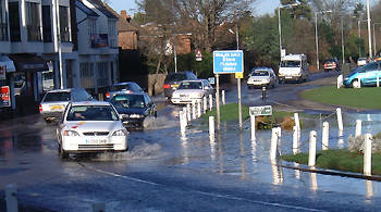
Tuesday 7th January 2003
River levels are now falling
in both Windsor and Datchet areas and are forecast to continue
to fall slowly. On Tuesday morning levels were approximately
1' (30cm) lower than at their peak on Sunday night. The railway
line between Windsor and Staines that was closed due to flooding
at Datchet on Sunday evening at 5pm resumed on an hourly basis
at midday on Tuesday as flood water on the track had subsided.
A belated track inspection that should have taken place "at
first light" was reported to be in progress at 10.15am with
the chance that train services would resume shortly thereafter,
assuming that no damage to the track had taken place. Damage
was unlikely as the water was not fast flowing, merely standing
water in a slight dip in the track on the approach to Datchet
Station. (Pictures above). The hourly
service is currently being supplemented by a bus service between
Windsor and Staines until train departures get back to normal.
The Brocas at Windsor is no longer under water, apart
from some standing water, and the large areas of flood water
over the Home Park are now receding. Levels currently are around
the level of December
2000, the last
occasion when the river was seriously in flood.
Wednesday 8th January
2003
Although a Flood Watch
remains in force for the river Thames at Windsor, the serious
threat to property of the last few days is now receding as river
levels fall. Train
services between Windsor and Staines
on the Waterloo line had been suspended from Sunday 5th January
at 5.00 until Tuesday 7th January due to track flooding at Datchet,
but have now returned to normal. Previously mild but wet weather
during December and over the New Year has now been replaced with
freezing conditions, with very light snow from time to time.
For reactions and news in the coming days and weeks see The
Aftermath of the Floods of January 2003
Thursday 9th January 2003
Flood Warnings Status
The Environment Agency Flood Warnings for
the river Thames between Maidenhead and Windsor have been as
follows in the past year:
Flood Watch, 08:28 on 05-Feb-2002
All Clear, 10:55 on 09-Feb-2002
Flood Watch, 14:39 on 02-Jan-2003
All Clear, 10:38 on 09-Jan-2003
Saturday 11th January
2003
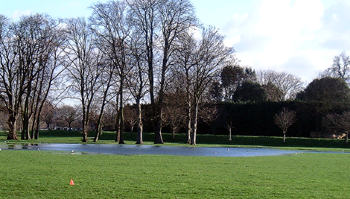
On Saturday 11th January, following almost
a week of freezing weather, with night time temperatures in the
region of -9°C and daytime rarely above 2°C, the flooded
Home Park had become an ice rink! Flood waters had receded, leaving
behind a vast area of thick ice, much enjoyed by youngsters who
seemed not to care about falling flat on their backs more than
once!
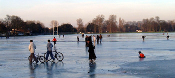 Thick ice covers a vast area of
The Home Park
Thick ice covers a vast area of
The Home Park
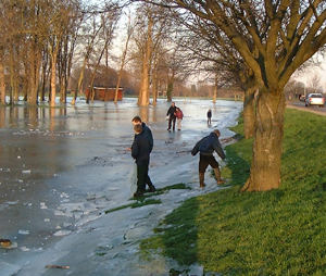 The ice marks the highest point
as the flood waters recede from beneath the ice.
The ice marks the highest point
as the flood waters recede from beneath the ice.
On Wednesday, 08 January
2003, the Royal Borough issued the following Press Release
Floods - Royal
Borough In Action
The Royal Borough's operations team swung
into action at the weekend when floods engulfed large areas of
the borough, leaving 500 homes surounded by water and hundreds
of residents marooned.
Worst-affected areas were Wraysbury in the east,
with 350 properties affected - where 20 residents had to be evacuated
from their homes as flood waters rose sharply on Saturday afternoon
- and Bisham, Hurley, Temple and Cookham in the west, with 150
homes hit.
Residents in 30 properties on Friary Island in Wraysbury
were completely cut off, with Wharf Road, Ouseley Road and The
Island also under water. In some areas, water levels rose by
as much as four feet over the weekend.
Operations team staff worked round the clock from
Thursday night and throughout the weekend in response to the
thousands of calls from worried residents to the council's depot
in Windsor:
- staffing the 24-hour emergency control
room
- making up and distributing more than 30,000
sandbags to householders
- sending out reconnaissance teams to assess
the worst-hit areas
- closing roads across the borough as they
became impassable, in response to requests from the police
- assisting the fire service with the evacuation
of residents
- helping the ambulance service attending
calls from flooded areas including "boating"
ambulance crews to one property.
By early yesterday (Monday) water levels
had peaked but the sandbag-making continued and the operations
team were preparing to set up diversion routes where roads were
still impassable.
Operations unit staff also organised and operated
two hovercraft provided by the charity Associated Search
and Rescue Hovercrafts (ASRH) to supply a temporary "bus"
service for local residents, ferrying them to and from their
homes until flood waters subside.
Cllr Derek Wilson, lead member for public protection,
said: "This has been a major flooding incident. The
scale of the damage is immense, particularly in Wraysbury. It
has been a very traumatic time for a great many people whose
properties have been under threat after water levels rose very
quickly on Saturday.
"I would like to pay particular tribute to our
dedicated operations team who have been working flat out all
over the weekend, with staff on duty round the clock answering
calls in the emergency control room and filling sandbags to keep
up with demand.
"We have worked closely with the police and
fire service with members of both forces based at our control
room to offer asistance to as many people as possible.
"Now our task will be to ensure we continue
to work together to help people cope with the aftermath of the
floods and return to normal as soon as possible."
There had been a minor
flood in December, but nothing much except that the ground was
becoming saturated, and the snow represented whole lakes of water
if there was a sudden thaw. And there was. In addition, heavy
rain fell on March 10th, followed by even heavier rain - nearly
one inch (2.5 cm). On March 14th the thawing snows could not
drain into the frozen ground and so the water continued down
hill into the streams and rivers. These rose at an alarming rate
- sometimes almost a foot (30 cm) an hour. Old hands prepared
to visit relatives living on high ground. The Thames topped its
banks on 14th March...
See Also
Back
to News in 2003
The
Royal Windsor Home Page
|