Thamesweb Logo


Histories of Windsor

The Victorian Floods in Windsor
1869, 1872, 1875, 1877, 1891 and 1894

Whenever the Thames is in flood, information is included on The Royal Windsor Home Page

Related stories

Forum relating to 2014 Flood Event

River Thames Index

The Windsor Floods of 1947

The Flood Relief Scheme
Index

The Thames in Flood - November 2000

Locks and Weirs on the
River Thames

The Thames in Flood - December 2000

Windsor History Home Page

Royal Windsor Home Page


Introduction

It is not widely known that in Victorian times, Windsor, and also the rest of the country, suffered flooding far more regularly than in the 20th century. Although this can partly be blamed on less effective river management, there must also be an element of extreme weather conditions. For example, a particularly severe flood seems to have occurred in 1852, the Illustrated London News reporting that the floods of December 1872 were some two feet lower than the floods of 1852. It has also been reported that a severe flood, possibly worse than 1894 occurred in 1774. Here we reproduce various reports and pictures published in the 19th century sometimes with unimaginative headline writing!

January 1869

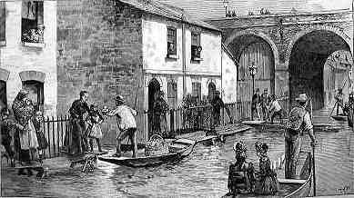
From The Illustrated London News January 16th 1869

THE LATE FLOODS

The extraordinary quantity of rain that has fallen in most parts of England during the last three weeks has caused the overflow of many rivers and the flooding of extensive tracts of land....

...The waters also rose considerably at Windsor and Eton where the scene was indeed remarkable as viewed from the north and east terraces of Windsor Castle. For several miles the natural course of the river and its windings were lost in a succession of inland lakes. Between Maidenhead and Staines thousands of acres of meadow and pasture land were inundated, the ditches, watercourses and rivulets being filled to overflowing. At Eton College portions of the playing fields were under water, the Brocas on the west side of the town, where the spectators assemble on June 4th to see the regatta was likewise partly submerged The south meadow, well known as the site upon which are celebrated the annual college athletic sports, formed the bottom of a fine sheet of water. In fact the town and college of Eton appeared to be situated upon a peninsula, so much water was lying west and east of the town. Upon the south shore of the river the swollen Thames had invaded the royal demesne, much of the Home Park facing the north and east terraces of the castle being under water. The land in the western environs of Windsor had a deal of water upon it, The Goswells, adjoining the Gardner estate, and near the Windsor gas works were partly inundated and the floods surrounded Taylor's baths. ... Except the rapid flow of the current, there was a remarkable aspect of stillness about the flooded valley.

floods Jan 1869

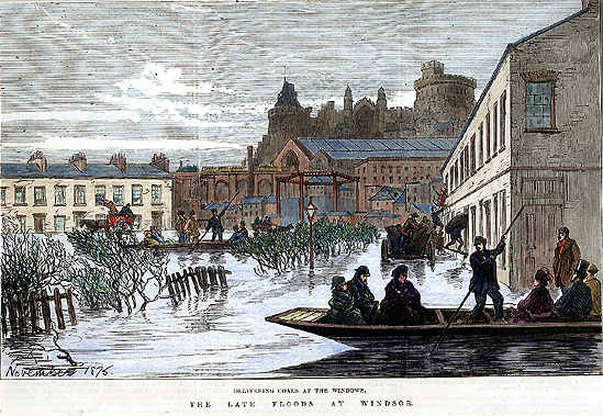
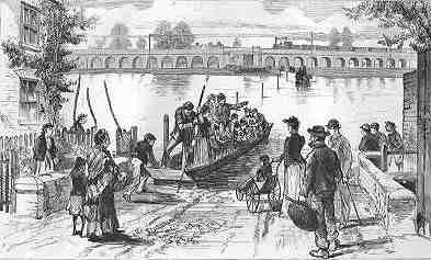
The flood in Windsor in January 1869 pictured in The Illustrated London News.
A similar view was to be published during the floods of November 1875, see below.

January 1872

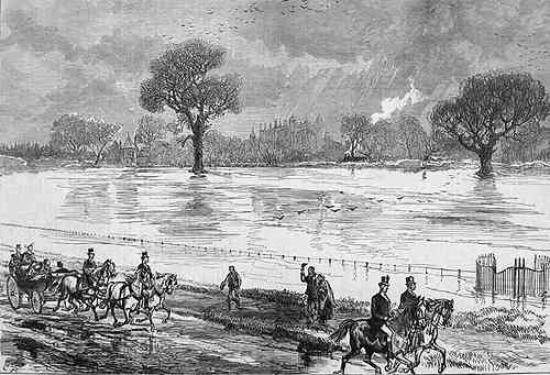
From TheGraphic Magazine February 10th 1872. p.137

THE FLOODS AT WINDSOR AND ETON

Floods January 1872

Thursday and Friday 25th and 26th January 1872.
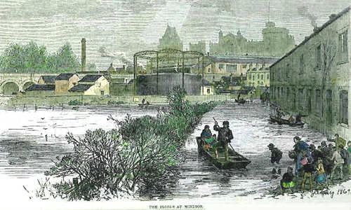
A view from the GWR railway viaduct towards Windsor, with the floodwater reaching the lower areas of the town.

In the course of Thursday the 25th and Friday the 26th ult. the water of the Thames rose considerably in the Windsor and Eton district, and as a consequence large tracts of land were inundated by the floods which have poured down the river from the west country

Between Maidenhead and Windsor much of the land on the banks of the Thames was under water, the choked rivulets and ditches adding to the inundation. At Clewer the stream rolled over portions of the Rays on which is situated the Windsor racecourse. Parts of the South Meadow west of Eton and also of the Playing Fields near Eton College were submerged, and much of Romney Island was under water, which rose on the Home Park opposite the Castle. The inundation spread round Taylor's Baths on the Windsor side of the river, and the swollen stream, rushing rapidly between the two towns, washed into Goodman's s boathouse, Salter's and Tolladay's, being threatened with a similar visitation.

In the Datchet, Wraysbury, and Staines districts there was also much land under water, the the. flood being more extensive than has been witnessed for the last two or three years.

On the 30th the floods began to subside and the comparitively dry weather since experienced has relieved the land of its watery burden. Similar floods have taken place in Nottinghamshire, Leicestershlre, and in the west of England.

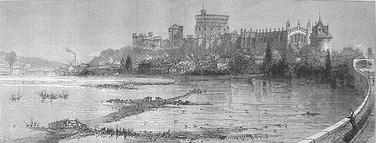
December 1872 & January 1873

From The Illustrated London News January 4th 1873

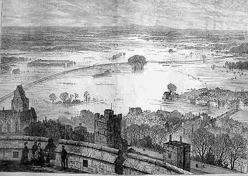
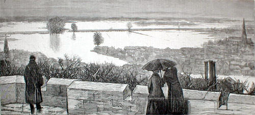
THE LATE FLOODS

The valley of the Thames, from Staines to above Windsor, and up to Maidenhead, presented an extraordinary spectacle during the floods, which covered miles of the low lands on each bank of the river in the week before Christmas. The lower parts of the town at Windsor and Eton were inundated to a depth of several feet in some places, so that the inhabitants of Cambridge Terrace and Oxford Road were obliged to use punts to and from their dwellings. When Divine worship was performed on the Sunday at the parish church of Bray, half a dozen boats were constantly employed to bring the congregation over the adjacent water; and the country people coming to market on other days reached Maidenhead by a similar conveyance. The view from the Round Tower of Windsor Castle, which is shown in the Illustration below, was exceedingly strange. The Eton College playing fields, the Brocas and the neighbouring meadows, the ground about the Provost's Fishing Lodge at Black Potts, and Romney Isle, below the bridge, with a vast extent of land at Chalvey, Eton Wick, and Dorney, were submerged. The town and college were almost surrounded with water, and converted into a peninsula. In the opposite direction the floods covered nearly all the Home Park to the north and east of the castle, and spread over the meadows of Datchet, Old Windsor, Magna Charta Island and Runnymede to Staines Moor. The flood here was not, indeed, so high by 2 ft. as that of 1852, which was the highest on record, and much relief was afforded by the newly-constructed weirs and tumbling bays near Windsor, as appears from a letter of Mr W. Menzies, Deputy Surveyor of the Royal Park. The works of the Windsor Castle Sewage Farm went on without interruption.

1873 from round tower

The Floods of early January 1873 from The Round Tower


November 1875

Floods 1875

A tinted and slightly stylised view of flooding around The Goswells in November 1875

Another flood occurred in Windsor in 1875 and the picture above was published by The Illustrated London News in November of that year. The view is approximately to the north from Charles Street. The houses to the left are in Arthur Road and remain to this day (2002). Immediately beneath the castle is the original canopy over the Central Station, rebuilt in the 1890s and still in existence today. A steam engine can be seen leaving the station on its way to Slough over the - admittedly exaggerated - high arches over Goswell Road that leads to the river beyond. In the centre of the picture are the cast iron supports for the gas holder at the gasworks on the site now occupied by Windsor Dials. The houses to the right were demolished some years ago to make way for The King Edward Car Park and King Edward Court. To the left of this view today stands Ward Royal.
  The level of the flood waters is very high, quite possibly higher than in 1894 and 1947. Our major flood story about The Floods of 1947 is available here. Other records about floods in the Windsor area will be published as time permits and the information becomes available. [Index to other Thames stories]

In our story about the film Carry On Cabby, we feature these views of the Arthur Road roundabout as it was in 1963, little changed since Victorian times. Although similar, we have included both these views to illustrate the Gas Board land to the right which was a car park by 1963, as well as the houses in Arthur Road to the left. The Noah's Ark pub is beside the roundabout.

Windsor Dials Feb 2000

A view of the same area taken in February 2000. Some of the terraced houses in Arthur Road and a pub on the corner beyond the roundabout have been demolished but the railway arches are still visible beyond the Windsor Dials office complex.


December 1876 - January 1877

Another flood occurred a little over a year later of similar severity judging by the illustration below, published by The Graphic magazine in January 1877. The picture was drawn at a position on the North Terrace of Windsor Castle looking out towards The Brocas (inundated) and Eton to the right. Running from left to right across the picture are the arches of the Great Western Railway viaduct linking Windsor with the main line at Slough. Just visible between some trees, top left, is the railway bridge over the main stream of the river Thames.

Floods 1877

A view west, January 1877. See text above.

Floods of 1875

The flooding in December 1876 extended into January 1877. This view shows the Home Park inundated and only the raised roadway to Datchet, constructed in 1851, still passable. Looking north, Eton College Chapel is in the distance, centre, with a steam train arriving from Datchet just to the right.

1891

Yet another flood occurred in 1891 and reported in The London Illustrated News who published the following two illustrations.

Goswells 1891

Floods in 1891 adjacent to the railway arch over Goswell Road.
Windsor Central Station is to the left and the railway goods yard, subsequently the coach park in 2002, to the right. A photograph of the same area is included below from the 1894 Floods.

Ferry 1891

Another view of the 1891 floods apparently across the river towards Windsor but in fact we believe that it is a view west from Eton towards Eton Wick, with fence posts marking the roadway and the GWR arches, their height exaggerated.

1894

In 1894 a major flood inundated Windsor, the highest until the floods of 1947.

Goswells Flood 1894

Floods in 1894 viewed from beneath the railway arch over Goswell Road, in the same area as the 1891 view above, looking towards the river. The church in Eton emerges through the mist. The railway goods yard, subsequently the coach park in more recent times, is to the left with the area that was to become Alexandra Gardens in the distance on the left. Bridgewater Terrace is to the right, out of shot.

Goswells Floods 1894

Floods in 1894 from the railway arches looking towards the river, with Goswell Road to the left. The area now known as The Goswells is centre right.

There were also floods in February 1899 and January 1912, during which ice formed over the Home Park. Photographs exist of skating on the Home Park at that time. (Windsor As It Was. Maitland Underhill. 1972. Hendon Publishing.)
  Flooding also occurred in January 1926, and 1929, and again in January 1936, peaking on 3rd January. It is quite possible that other floods and freezes took place in other years, but so far we have not come across references or images. The last major flood of the 20th century in Windsor was in 1947 [The Windsor Floods of 1947]
. In the 21st century some flooding ocurred in January 2003 downstream of Windsor. Residents of Wraysbury were convinced that this was due to the incorrect and rushed operation of the newly completed Jubilee River (Flood Relief Scheme) . Our other flood related stories are linked below.

Floods in other Eras

In the course of researching the above article, we have also found references to floods in 1915, 1912, 1841, 1821, 1819, 1774 when Henley Bridge was swept away, 1768, 1764 and 1742.


Related stories

Forum relating to 2014 Flood Event

River Thames Index

The Windsor Floods of 1947

The Flood Relief Scheme
Index

The Thames in Flood - November 2000

Locks and Weirs on the
River Thames

The Thames in Flood - December 2000

Windsor History Home Page

Royal Windsor Home Page


Thamesweb Logo

To contact us, email Thamesweb.